

ALS
Operating Geodetic Survey Systems with UAVs
Enrol on a professional course on operating geodetic survey systems with UAVs: aerial imaging, photogrammetry, GNSS post-processing, and LiDAR data processing.
You will master the full workflow — from flight planning and field data capture to producing point clouds, orthomosaics and 3D models in production-ready formats. Training is delivered on the client’s site. We work across Europe and on projects worldwide.
The programme is designed to train professionals working with unmanned aircraft systems, photogrammetry and laser scanning.
Who this course is for
A hands-on course on using UAVs for surveying workflows: mission planning and data capture, photogrammetry and airborne laser scanning acquisition, followed by processing, quality control, and delivering outputs for CAD/GIS use and client acceptance.
Audience
Surveyors and cadastral professionals
When the result must be measurable, verifiable, and suitable for downstream engineering workflows.
- Cadastre and surveys: orthomosaics, DTM/DSM, topographic plans
- As-built surveying: 3D / point clouds, design vs as-built checks, geometry control
- Georeferencing and accuracy: GCPs/CPs, PPK/GNSS, QA criteria and fitness-for-purpose
Audience

Mine surveyors and mining engineers
When you need fast coverage of large areas with clear quality control and repeatable results.
- Open pits and spoil heaps: volumes, change tracking, periodic reporting
- Slopes and benches: geometry control, change detection and risk areas
- Field QC: coverage, critical zones, gaps, and go/no-go decisions for re-flights
Audience
Remote sensing / GIS specialists, designers, client engineers
When temporal consistency, deliverable structure, and integration into CAD/GIS workflows matter.
- Monitoring: repeat surveys and surface/point-cloud comparison
- Construction control: as-built models, schedules, progress verification
- Deliverables: CAD/GIS formats and structure, tiling by zones, agreed deliverable scope
Entry requirements: applicants must have relevant professional qualifications or a higher-education degree.
Course objectives and outcomes
The course provides a technically sound, repeatable workflow for using industrial UAVs in surveying — from preparation and QA/QC to producing deliverables you can use on site and submit to the client.
By the end of the course, you will have
- A clear end-to-end UAV workflow: what to do, in what order, and which checks are mandatory
- Practical checklists: pre-flight preparation, field QA/QC, and criteria for “ready to process / needs re-flight”
- An understanding of which acquisition parameters truly affect accuracy and output quality (and how to select them for the task)
- The ability to diagnose common issues from symptoms: overlaps/coverage, motion blur/exposure, georeferencing, trajectory, LiDAR geometry
- A proven “capture + processing” workflow, using your data or a training dataset (as agreed)
- Final outputs you can use immediately: orthomosaic, point cloud and 3D model (content and formats depend on the task)
- Confidence in delivering results for CAD/GIS and meeting acceptance requirements (including what and how to check)
Course programme
8 modules: theory, practice and final assessment. Practical sessions cover flight scenarios, QA/QC and deliverable preparation.
Flight theory and safe UAS operations
Risk management, pre-flight preparation, checklists, baseline requirements, and on-site workflow.
Multirotor UAV piloting
Piloting modes, scenario-based practice, stability, manoeuvre accuracy, and operation in typical site conditions.
Software-based mission planning
Mission parameters: altitude, GSD, overlaps, speed, constraints, coverage checks and critical zones.
Operating airborne and mobile LiDAR scanners
Setup, field data capture, operational specifics, density and geometry checks, and initial point-cloud QA/QC.
GNSS post-processing (PPK)
Post-processing, quality checks, alignment with survey data, and verification of solution accuracy and stability.
Photogrammetric processing
Alignment, orthomosaics and models, common issues (overlaps, blur, exposure, weak areas) and prevention.
Trajectory and LiDAR point-cloud processing
Trajectory solution, initial point cloud, filtering and classification, QA/QC, and preparation of final datasets.
Final assessment
Verification of key skills and assembly of final deliverables for a case study.
32 hours
8 hours of practical training
In-person / on-site
Assessment
Training format
Delivered in person at the client’s site. Travel and accommodation costs are charged separately.
Venue and delivery
In-person group
Classroom sessions plus on-site practice focused on photogrammetry and airborne laser scanning data capture.
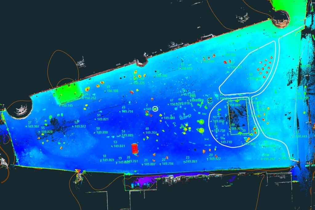
Examples of materials and practical sessions
Course outcomes
You will leave with a tangible set of deliverables and skills to independently complete professional UAV-based surveying tasks.
What you take away
Materials + checklists + a clear workflow
Everything you need to repeat the process on real sites and confidently meet acceptance requirements.
- Survey outputs: point cloud, orthomosaic, 3D model (content and formats depend on the task)
- QA/QC: “fit to process / needs re-capture” criteria, typical failure causes, and prevention
- Georeferencing and accuracy: understanding GCPs/CPs, PPK/GNSS, and what truly affects the outcome
- CAD/GIS-ready delivery: structure, formatting, handover preparation and verification
Project examples
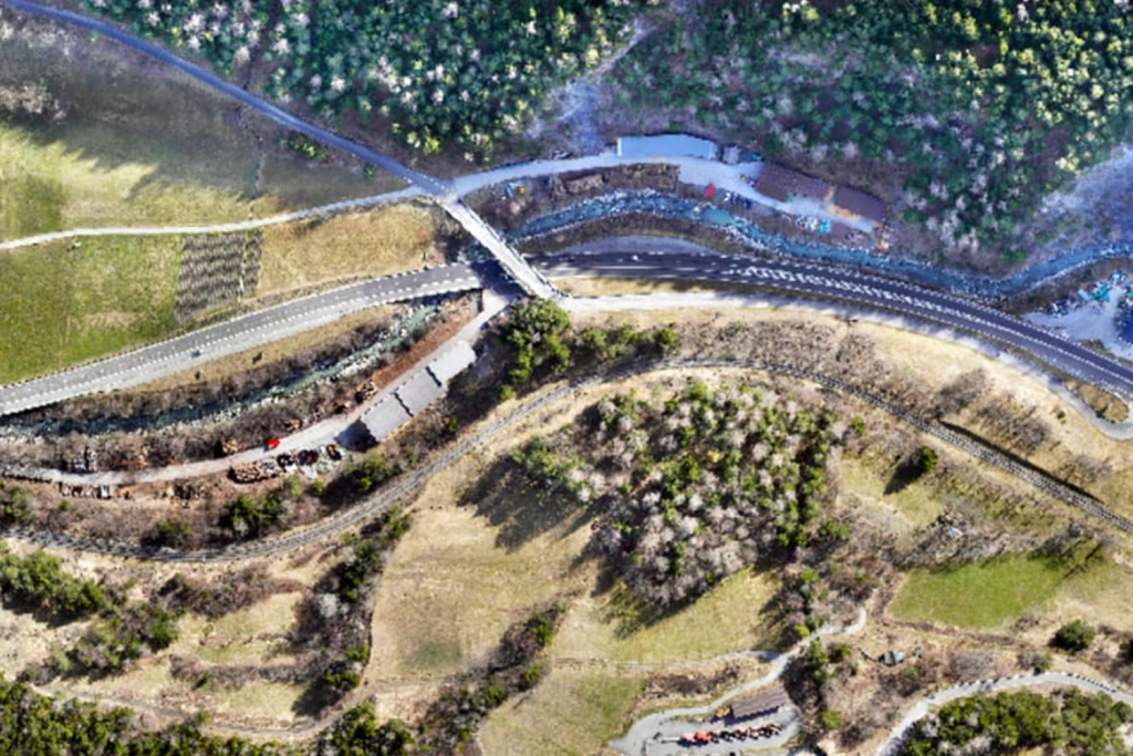
ALS and MLS
Scanning mountainous and forested terrain
Not sure about something?
If you have any questions or need advice, email us at info@topodrone.com — we’ll be happy to walk you through the details and recommend the most effective way to use UAVs in your field.
