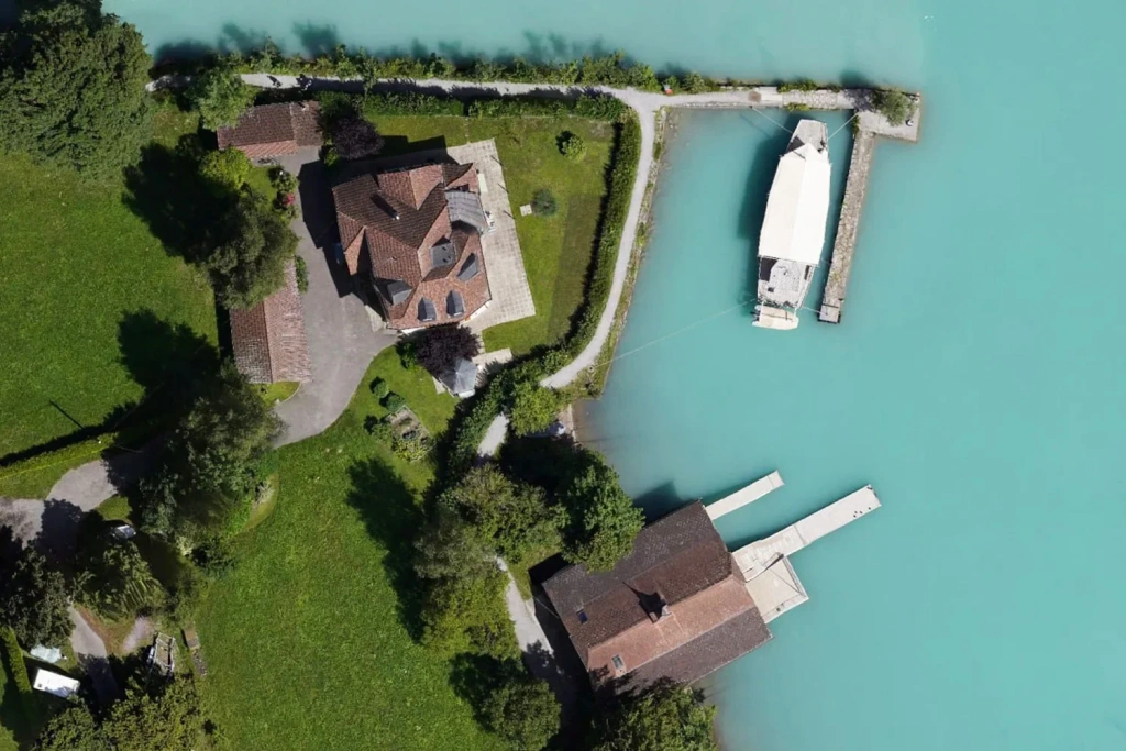
Knowledge base
Blog
Services
  • Aerial Photography
    • UAV Monitoring & Inspections
    • UAV Photogrammetry
  • Laser Scanning
    • Aerial Laser Scanning
    • Quarry Surveying
    • Topographical Surveying
  • Training
    • UAV Pilot Course: Photogrammetry & ALS
Company
  • Staff
  • News
  • Reviews
  • Vacancy
  • Licenses
  • Documents
  • Partners
Information
  • Requisites
Brands
Contacts
    +41 21 588 02 11
    +41 21 588 02 11 09:00-18:00 whatsapp.svg
    Sales [email protected] email.png
    Support [email protected] email.png
    Telegram Channel @topodronesa tg.svg
    Telegram Chat @topodronesagroup tg.svg
    Telegram Bot @topodronecombot tg.svg
    Facebook @topodronesa ycz1c9257s6gh7g315r8q6tob3bnddba.png
    Youtube @topodronesa youtube.png
    LinkedIn @topodrone 9ratq3v3eavnhupo1akvxp0sbx4vopj5.png
    X @topodrone twitter.png
    Instagram @topodrone tpxkj71axu6dxt423lwj5idzwcej1njx.png
    Email
    [email protected] - Sales
    [email protected] - Support
    The address
    TOPODRONE SA, Rue de la Gare 13, 1820 Montreux, Switzerland
    Working hours
    10:00-18:00
    TOPODRONE
    SPH Engineering
    3Dsurvey
    Velodyne
    DJI
    GreenValley International
    Honeywell
    Fixar
    Blue Marble Geographics
    Sony
    Agisoft
    EMLID
    Pix4D
    Autel Robotics
    SHAREUAV
    • LiDAR
      LiDAR
      • Aerial Survey LiDAR
      • SLAM Survey LiDAR
      • LiDAR Accessories
    • Bathymetry
      Bathymetry
    • Photogrammetry
      Photogrammetry
      • Mapping Drones
      • Drone Mapping Cameras
      • VTOL Mapping Cameras
    • PPK Upgrade Kits
      PPK Upgrade Kits
      • PPK for Drones
      • PPK for any UAV
    • Spectrography
      Spectrography
      • Thermal
      • Multispectral
    • UAV
      UAV
      • DJI
      • Autel Robotics
      • FIXAR
      • Innotech drone
    • Payload
      Payload
      • Aerial Survey LiDAR
      • Bathymetric Scanner
      • Photogrammetric Cameras
      • Thermal Cameras
      • Multispectral Cameras
      • Beacon
    • Software
      Software
      • TOPODRONE
      • UgCS
      • Agisoft
      • 3Dsurvey
      • LiDAR360
      • DJI
      • PIX4D
    • GNSS Equipment
      GNSS Equipment
      • EMLID
      • DJI
    TOPODRONE – LiDAR & UAV Survey
    Log in
    0 Comparison
    0 Favorites
    0 Cart
    TOPODRONE – LiDAR & UAV Survey
    Log in
    0 Comparison
    0 Favorites
    0 Cart
    TOPODRONE – LiDAR & UAV Survey
    Telephones
    +41 21 588 02 11 09:00-18:00 whatsapp.svg
    Sales [email protected] email.png
    Support [email protected] email.png
    Telegram Channel @topodronesa tg.svg
    Telegram Chat @topodronesagroup tg.svg
    Telegram Bot @topodronecombot tg.svg
    Facebook @topodronesa ycz1c9257s6gh7g315r8q6tob3bnddba.png
    Youtube @topodronesa youtube.png
    LinkedIn @topodrone 9ratq3v3eavnhupo1akvxp0sbx4vopj5.png
    X @topodrone twitter.png
    Instagram @topodrone tpxkj71axu6dxt423lwj5idzwcej1njx.png
    Email
    [email protected] - Sales
    [email protected] - Support
    The address
    TOPODRONE SA, Rue de la Gare 13, 1820 Montreux, Switzerland
    Working hours
    10:00-18:00
    0
    0
    0
    • Cabinet
    • 0 Compare
    • 0 Favorite
    • 0 Cart
    • Brands
    • Sales
    • Services
      • Services
      • Aerial Photography
        • Aerial Photography
        • UAV Monitoring & Inspections
        • UAV Photogrammetry
      • Laser Scanning
        • Laser Scanning
        • Aerial Laser Scanning
        • Quarry Surveying
        • Topographical Surveying
      • Training
        • Training
        • UAV Pilot Course: Photogrammetry & ALS
    • Company
      • Company
      • Staff
      • News
      • Reviews
      • Vacancy
      • Licenses
      • Documents
      • Partners
    • Blog
    • Information
      • Information
      • Requisites
    • Contacts
    +41 21 588 02 11 09:00-18:00
    • Telephones
    • +41 21 588 02 11 09:00-18:00
      whatsapp.svg
    • Sales [email protected]
      email.png
    • Support [email protected]
      email.png
    • Telegram Channel @topodronesa
      tg.svg
    • Telegram Chat @topodronesagroup
      tg.svg
    • Telegram Bot @topodronecombot
      tg.svg
    • Facebook @topodronesa
      ycz1c9257s6gh7g315r8q6tob3bnddba.png
    • Youtube @topodronesa
      youtube.png
    • LinkedIn @topodrone
      9ratq3v3eavnhupo1akvxp0sbx4vopj5.png
    • X @topodrone
      twitter.png
    • Instagram @topodrone
      tpxkj71axu6dxt423lwj5idzwcej1njx.png
    • [email protected] - Sales
      [email protected] - Support
    • TOPODRONE SA, Rue de la Gare 13, 1820 Montreux, Switzerland
    • 10:00-18:00
    Main
    Services
    Aerial Photography
    UAV Photogrammetry

    UAV Photogrammetry

    UAV Photogrammetry

    Order a service

    Make a request for the service, we will contact you as soon as possible and answer all your questions.
    $0

    UAV Photogrammetry

    Our UAV photogrammetry service delivers measurable spatial data from a series of overlapping images. We handle both drone data capture and office-based processing, so you receive a reliable digital baseline for design, construction and analysis: orthophoto, point cloud, DTM/DSM and a 3D model in CAD/GIS/BIM-ready formats. We use TOPODRONE in-house camera systems to ensure consistent output quality.
    UAV photogrammetry

    What it’s best for

    Photogrammetry provides a measurable digital baseline — not “just photos”, but data you can calculate and make decisions with.

    Design

    Topographic baseline

    Topographic baseline from UAV data

    Orthophotos and terrain models to support design work and approvals, aligned to the brief.

    3D

    Buildings and structures

    3D modelling of buildings and structures

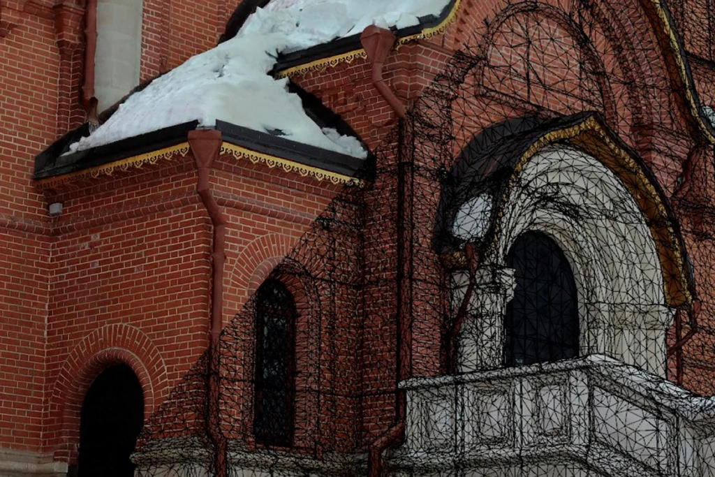
    3D reconstruction for measured surveys, façades, refurbishment, and geometry checks.

    Inspection

    Site condition surveys

    Site condition survey

    Clear visual evidence of the current state of land and assets for operations and planning.

    Volumes

    Cut/fill and stockpiles

    Volume calculations from UAV data

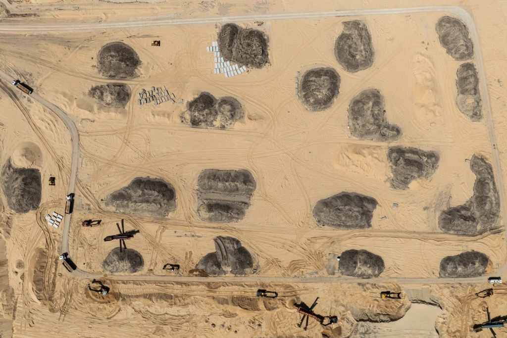
    Volume computations and reporting for selected zones and boundaries.

    Construction

    As-built and progress tracking

    Construction progress tracking (before/after)

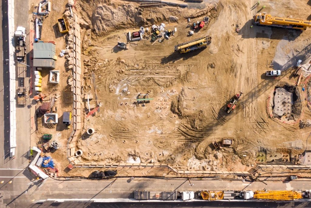
    Time-stamped site records, period comparisons (before/after), and progress control.

    Linear assets

    Railways, roads, power lines

    CAD/GIS/BIM integration

    Accurate geometry for measurements, asset inventories, and deformation/damage monitoring.

    What you receive

    The deliverable set is agreed in the project brief. Below are typical outputs for design and control tasks.

    Mapping

    Orthophoto and orthomosaic

    Orthophoto and orthomosaic

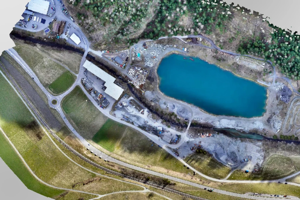
    A georeferenced orthophoto and, when required, a seamless orthomosaic with brightness balancing. Ideal for measurements, CAD/GIS underlays, and documenting site condition.
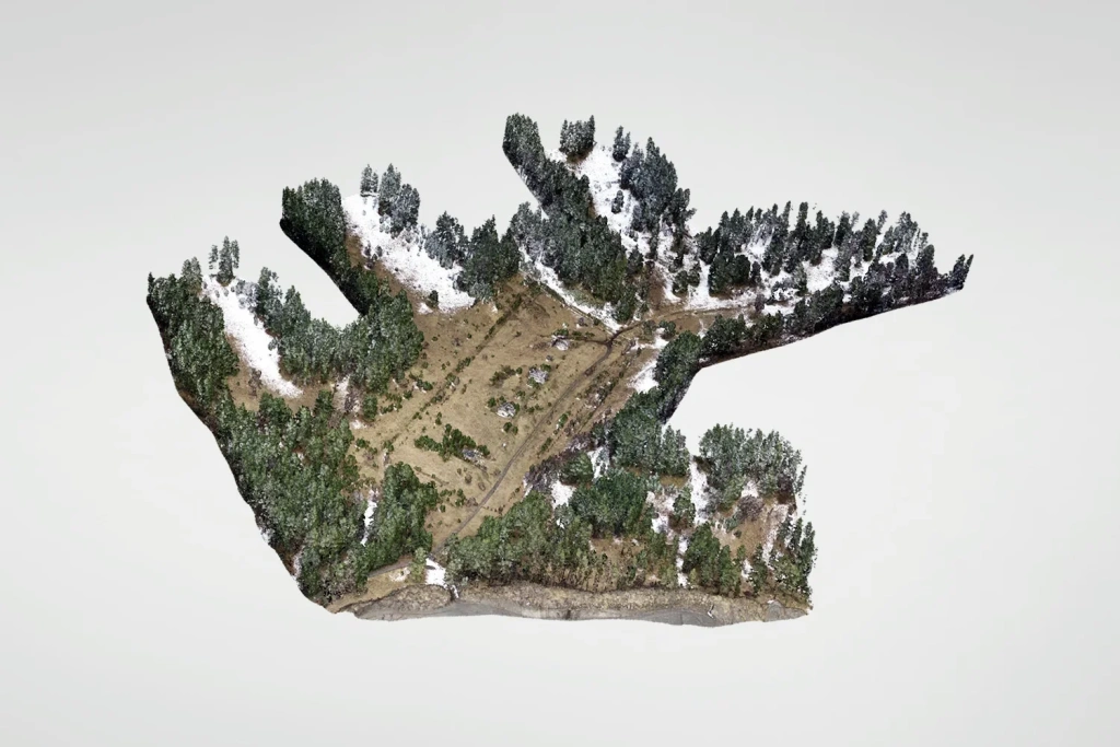
    3D & measurements

    Point cloud, DTM/DSM, 3D model

    Point cloud and 3D models

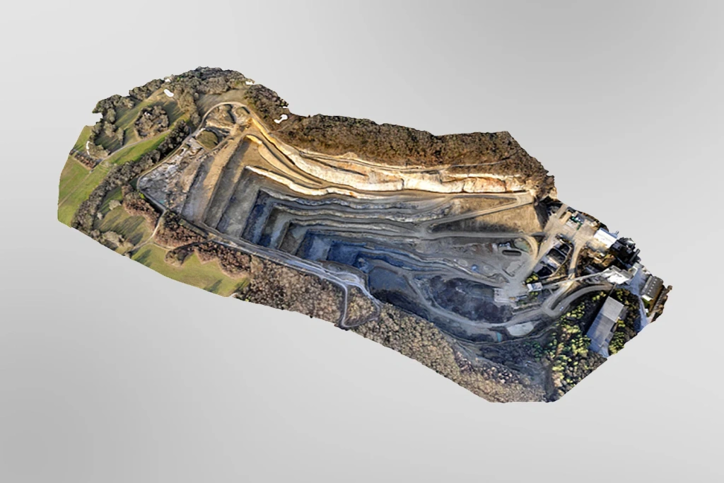
    A point cloud and digital terrain/surface models for profiles, sections, elevations and calculations. On request — a 3D mesh (textured or untextured) for visualisation and measured surveys.

    Export formats

    Delivered in agreed formats: GeoTIFF, LAS/LAZ, DXF/DWG, PDF and more. The final output list is fixed in the brief before work starts.

    When photogrammetry is the best choice

    Efficient

    Open areas and “readable” surface texture

    Photogrammetry performs best on open sites, quarries and construction projects where the surface is clearly visible, and where orthophotos and 3D visualisation are key.

    Important

    Terrain under dense vegetation

    If you need reliable ground models beneath canopy, airborne laser scanning (LiDAR) or a combined approach is usually a better fit. We’ll recommend the optimal option during a consultation.

    How we deliver the work

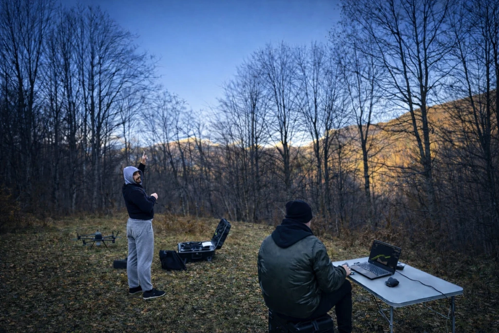
    A transparent workflow: planning → capture → processing → quality control → delivery.

    Workflow

    We agree the brief, carry out the survey and office processing, then deliver the final dataset.

    Free consultation Brief & formats Flight plan Data capture Processing

    Define the requirement

    Accuracy, coordinate reference system, deliverable set, timeline and site constraints.

    We agree
    • Accuracy requirements.
    • CRS and export formats.
    • Timeline and site restrictions.

    Flight planning

    Altitude, overlaps, routes and scenarios for complex terrain and objects.

    We prepare
    • A flight plan.
    • Capture parameters and overlaps.
    • Routes and risk zones.

    UAV data capture

    Capture to plan; where required — ground control / check points to tie and verify results.

    We control
    • Full coverage with no “blind spots”.
    • Source data quality.
    • Where required — GCPs / checks.

    Office processing

    Alignment, point cloud, models, orthophoto/orthomosaic, and project outputs as per the brief.

    We produce
    • Point cloud and models.
    • Orthophoto/orthomosaic.
    • Deliverables defined in the brief.

    Quality control & delivery

    Quality checks, export to agreed formats, and delivery of the final dataset.

    We deliver
    • The final dataset.
    • Exports in agreed formats.
    • Short guidance on contents.

    Timeline and pricing

    Pricing is provided after a short brief. Payment is based on completed work.

    Timeline

    From 1–2 days to several weeks

    Depends on area, required level of detail and the scope of office processing. We confirm the schedule and milestones before work starts.

    Pricing

    Quoted on request (after the brief)

    Cost depends on area, required accuracy, site complexity, deliverables and whether control points are needed.

    For a quick quote: location and site type, approximate area/boundaries, goal (“orthophoto”, “3D”, “volumes”, “before/after”), coordinate system (if relevant), export formats and desired timeline.

    Project examples

    Survey for calculations and monitoring

    Aerial photogrammetry & airborne LiDAR

    Built-up area and quarry survey in Sangaredi, Guinea

    Read more
    Aerial photogrammetry & airborne LiDAR in mountainous terrain

    Aerial photogrammetry & airborne LiDAR in mountainous terrain

    Aerial photogrammetry & airborne LiDAR for a hydropower pipeline route

    Read more

    Image preview

    Not sure where to start?

    If you have questions or need a consultation, email us at [email protected] — we’ll walk you through the brief, deliverable formats and timelines.

    Back to the list
    Connect with us
    +41 21 588 02 11
    +41 21 588 02 11 09:00-18:00 whatsapp.svg
    Sales [email protected] email.png
    Support [email protected] email.png
    Telegram Channel @topodronesa tg.svg
    Telegram Chat @topodronesagroup tg.svg
    Telegram Bot @topodronecombot tg.svg
    Facebook @topodronesa ycz1c9257s6gh7g315r8q6tob3bnddba.png
    Youtube @topodronesa youtube.png
    LinkedIn @topodrone 9ratq3v3eavnhupo1akvxp0sbx4vopj5.png
    X @topodrone twitter.png
    Instagram @topodrone tpxkj71axu6dxt423lwj5idzwcej1njx.png
    Email
    [email protected] - Sales
    [email protected] - Support
    The address
    TOPODRONE SA, Rue de la Gare 13, 1820 Montreux, Switzerland
    Working hours
    10:00-18:00
    [email protected] - Sales
    [email protected] - Support
    TOPODRONE SA, Rue de la Gare 13, 1820 Montreux, Switzerland
    Products
    Sales
    Brands
    Services
    Applications
    Company
    Staff
    News
    Reviews
    Vacancy
    Licenses
    Documents
    Partners
    Information
    Requisites
    Help
    Payment
    Delivery
    Warranty
    FAQ
    © 2026 TOPODRONE SA
    Privacy Policy
    Main page Product 0 Comparison Contacts Blog Applications