Knowledge base
Blog
Services
  • Aerial Photography
    • UAV Monitoring & Inspections
    • UAV Photogrammetry
  • Laser Scanning
    • Aerial Laser Scanning
    • Quarry Surveying
    • Topographical Surveying
  • Training
    • UAV Pilot Course: Photogrammetry & ALS
Company
  • Staff
  • News
  • Reviews
  • Vacancy
  • Licenses
  • Documents
  • Partners
Information
  • Requisites
Brands
Contacts
    +41 21 588 02 11
    +41 21 588 02 11 09:00-18:00 whatsapp.svg
    Sales [email protected] email.png
    Support [email protected] email.png
    Telegram Channel @topodronesa tg.svg
    Telegram Chat @topodronesagroup tg.svg
    Telegram Bot @topodronecombot tg.svg
    Facebook @topodronesa ycz1c9257s6gh7g315r8q6tob3bnddba.png
    Youtube @topodronesa youtube.png
    LinkedIn @topodrone 9ratq3v3eavnhupo1akvxp0sbx4vopj5.png
    X @topodrone twitter.png
    Instagram @topodrone tpxkj71axu6dxt423lwj5idzwcej1njx.png
    Email
    [email protected] - Sales
    [email protected] - Support
    The address
    TOPODRONE SA, Rue de la Gare 13, 1820 Montreux, Switzerland
    Working hours
    10:00-18:00
    TOPODRONE
    SPH Engineering
    3Dsurvey
    Velodyne
    DJI
    GreenValley International
    Honeywell
    Fixar
    Blue Marble Geographics
    Sony
    Agisoft
    EMLID
    Pix4D
    Autel Robotics
    SHAREUAV
    • LiDAR
      LiDAR
      • Aerial Survey LiDAR
      • SLAM Survey LiDAR
      • LiDAR Accessories
    • Bathymetry
      Bathymetry
    • Photogrammetry
      Photogrammetry
      • Mapping Drones
      • Drone Mapping Cameras
      • VTOL Mapping Cameras
    • PPK Upgrade Kits
      PPK Upgrade Kits
      • PPK for Drones
      • PPK for any UAV
    • Spectrography
      Spectrography
      • Thermal
      • Multispectral
    • UAV
      UAV
      • DJI
      • Autel Robotics
      • FIXAR
      • Innotech drone
    • Payload
      Payload
      • Aerial Survey LiDAR
      • Bathymetric Scanner
      • Photogrammetric Cameras
      • Thermal Cameras
      • Multispectral Cameras
      • Beacon
    • Software
      Software
      • TOPODRONE
      • UgCS
      • Agisoft
      • 3Dsurvey
      • LiDAR360
      • DJI
      • PIX4D
    • GNSS Equipment
      GNSS Equipment
      • EMLID
      • DJI
    TOPODRONE – LiDAR & UAV Survey
    Log in
    0 Comparison
    0 Favorites
    0 Cart
    TOPODRONE – LiDAR & UAV Survey
    Log in
    0 Comparison
    0 Favorites
    0 Cart
    TOPODRONE – LiDAR & UAV Survey
    Telephones
    +41 21 588 02 11 09:00-18:00 whatsapp.svg
    Sales [email protected] email.png
    Support [email protected] email.png
    Telegram Channel @topodronesa tg.svg
    Telegram Chat @topodronesagroup tg.svg
    Telegram Bot @topodronecombot tg.svg
    Facebook @topodronesa ycz1c9257s6gh7g315r8q6tob3bnddba.png
    Youtube @topodronesa youtube.png
    LinkedIn @topodrone 9ratq3v3eavnhupo1akvxp0sbx4vopj5.png
    X @topodrone twitter.png
    Instagram @topodrone tpxkj71axu6dxt423lwj5idzwcej1njx.png
    Email
    [email protected] - Sales
    [email protected] - Support
    The address
    TOPODRONE SA, Rue de la Gare 13, 1820 Montreux, Switzerland
    Working hours
    10:00-18:00
    0
    0
    0
    • Cabinet
    • 0 Compare
    • 0 Favorite
    • 0 Cart
    • Brands
    • Sales
    • Services
      • Services
      • Aerial Photography
        • Aerial Photography
        • UAV Monitoring & Inspections
        • UAV Photogrammetry
      • Laser Scanning
        • Laser Scanning
        • Aerial Laser Scanning
        • Quarry Surveying
        • Topographical Surveying
      • Training
        • Training
        • UAV Pilot Course: Photogrammetry & ALS
    • Company
      • Company
      • Staff
      • News
      • Reviews
      • Vacancy
      • Licenses
      • Documents
      • Partners
    • Blog
    • Information
      • Information
      • Requisites
    • Contacts
    +41 21 588 02 11 09:00-18:00
    • Telephones
    • +41 21 588 02 11 09:00-18:00
      whatsapp.svg
    • Sales [email protected]
      email.png
    • Support [email protected]
      email.png
    • Telegram Channel @topodronesa
      tg.svg
    • Telegram Chat @topodronesagroup
      tg.svg
    • Telegram Bot @topodronecombot
      tg.svg
    • Facebook @topodronesa
      ycz1c9257s6gh7g315r8q6tob3bnddba.png
    • Youtube @topodronesa
      youtube.png
    • LinkedIn @topodrone
      9ratq3v3eavnhupo1akvxp0sbx4vopj5.png
    • X @topodrone
      twitter.png
    • Instagram @topodrone
      tpxkj71axu6dxt423lwj5idzwcej1njx.png
    • [email protected] - Sales
      [email protected] - Support
    • TOPODRONE SA, Rue de la Gare 13, 1820 Montreux, Switzerland
    • 10:00-18:00
    Main
    Services
    Laser Scanning
    Aerial Laser Scanning

    Aerial Laser Scanning

    Aerial Laser Scanning

    Order a service

    Make a request for the service, we will contact you as soon as possible and answer all your questions.
    $0

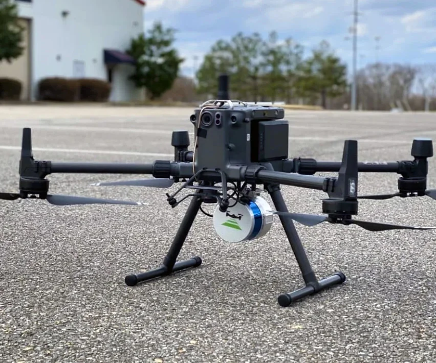
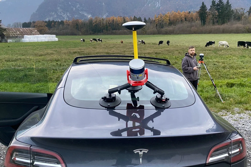
    We deliver LiDAR scanning for sites and assets of any complexity — from terrain and land parcels to buildings, linear infrastructure, industrial facilities and indoor environments — operating across Europe and on projects worldwide. Our deliverables are production-ready and fully compatible with CAD and GIS workflows.

    ALS / MLS Point cloud: LAS/LAZ, E57 DTM/DSM, profiles, cross-sections CAD / GIS / BIM Accuracy verified to brief
    LiDAR scanning of sites and assets

    Sites and sectors we work with

    Suitable for projects ranging from indoor spaces to large areas and long corridors.

    Construction

    As-built survey

    A solid baseline for CAD/BIM: capture as-is geometry, verify deviations, and update models and plans to date.
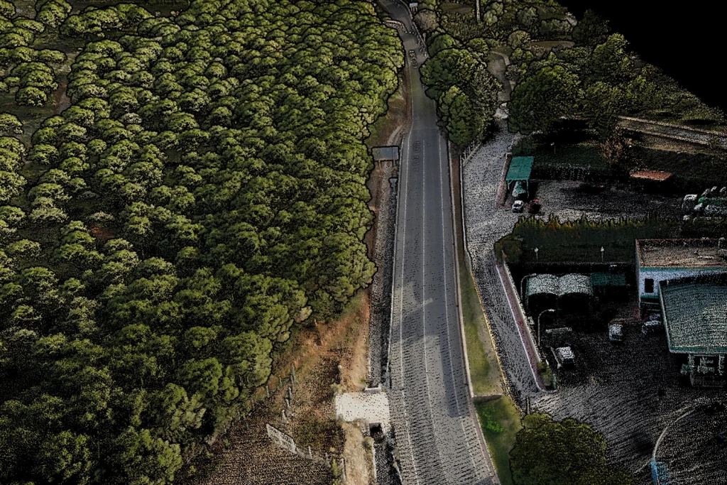
    Infrastructure

    Roads, corridors, urban environments

    Asset inventories, clearances, roadside furniture, cross-sections and route profiles.

    Industry

    Buildings, structures and steelwork

    Measured data to support refurbishment and retrofit design.

    Energy

    Power lines, pipelines, sites

    Corridor surveys and adjacent terrain capture, including clearance and crossing analysis (as per the brief).
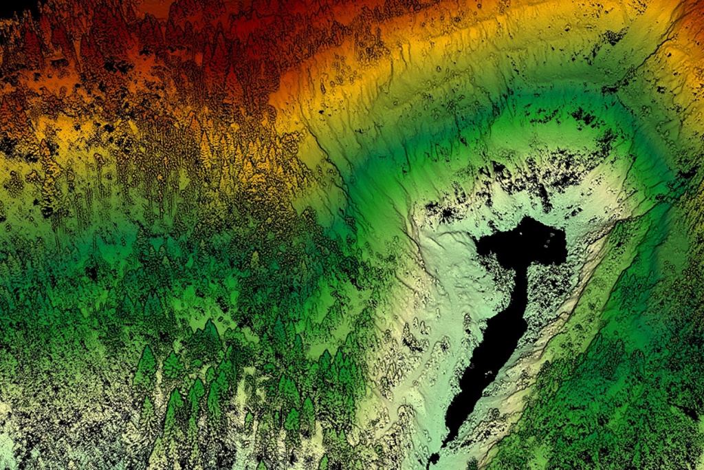
    Mining

    Quarries, stockpiles, complex terrain

    Terrain models, slope profiles, volume calculations and change monitoring between survey epochs.

    Forestry & agriculture

    Forest and agricultural surveys

    Tree-by-tree surveys, inventory and mensuration, crop field mapping, and biomass estimation.

    Typical LiDAR scanning tasks

    A practical set of use cases — from engineering baselines to change detection and analysis.

    Use cases

    • Engineering baseline: point cloud, surfaces, plans for CAD/GIS/BIM.
    • Profiles and cross-sections: along routes/corridors, specified lines, or chainage-based sections.
    • Design and refurbishment: accurate “as-is” geometry to avoid repeat site measurements.
    • As-built verification: verify delivered work, deviations and volumes (as per the brief).
    • Asset inventory: attribution of features (poles, fences, signs, drainage, cables, manholes and more).
    • Clearance checks: headroom, offsets, safe distances and crossings (to brief-defined criteria).
    • Mining: quarries/stockpiles, slope modelling, volume calculations, before/after monitoring.
    • Change detection: epoch comparison, difference maps, deformation dynamics (per monitoring method).
    • Challenging conditions: vegetation penetration (ALS), continuous corridor capture without stops (MLS).

    If your task is non-standard, describe the site, constraints and expected outputs — we’ll propose the best technology and deliverable set for your workflow.

    Three technologies for different site conditions

    We choose the approach based on scale, access, geometry and output requirements.
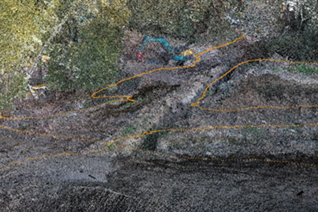
    ALS

    Airborne LiDAR (UAV)

    The best option for terrain, large areas, quarries, corridors and complex vegetation conditions.

    • Fast coverage for areas and long corridors.
    • Works well on slopes and complex terrain; canopy penetration depends on conditions.
    • Accuracy is fixed in the brief and verified through checks.

    MLS

    Mobile LiDAR (MLS)

    Ideal for linear assets and infrastructure: roads, streets, perimeters, industrial sites, façades and street furniture.

    • High detail along the capture route.
    • High productivity with minimal disruption to traffic (site-dependent).
    • Well suited to inventories and geodata updates.

    Airborne Laser Scanning enables the rapid survey of large areas and linear assets, while Mobile Laser Scanning provides higher-resolution capture of specific sections where greater detail is required.

    What we typically need from you to make the output genuinely useful

    A short checklist that saves time and reduces the risk of rework.

    Brief inputs

    To match the requirement precisely

    • Site boundaries: area/corridor, key zones and priorities.
    • Expected outputs: point cloud, DTM/DSM, profiles/sections, 3D, reporting.
    • Coordinate reference system and vertical datum: match your project setup.
    • Accuracy requirements and how they will be verified (checks, tolerances).
    • Your standards: layers, naming, units, DWG/DXF templates (if any).

    Site conditions

    To avoid wasting time on site

    • Access rules: permits, escort requirements, work windows, H&S requirements.
    • Constraints: UAV flight restrictions (ALS), traffic movement (MLS), restricted areas.
    • Conditions: vegetation, reflective surfaces, dust/smoke, water, tight passages.
    • Existing control/check points — or whether we can establish them (if needed).
    • Data delivery: media/cloud, folder structure, delivery timeline.

    Common add-ons

    What clients often add to LiDAR scanning

    • Point cloud classification (ground/vegetation/buildings/poles, etc.) for GIS and design workflows.
    • Feature extraction and asset inventories with layers/attributes.
    • Epoch comparison: difference maps, change tables, before/after control.
    • Profiles/cross-sections by chainage or specified lines (including cross-sections).
    • BIM prep: simplified model, coordinate referencing, clash checks (as per the brief).
    • QA/QC report: methodology, control checks and accuracy summary.

    Deliverables and formats

    We agree the file list and layer structure before starting. You receive “ready-to-use” outputs for your environment.

    Deliverable Format Contents
    Point cloud LAS/LAZ, E57 Merged and cleaned point cloud; classification if required
    Surfaces DWG/DXF DTM/DSM, contours, slopes, derivative maps
    Profiles and cross-sections DWG/DXF, PDF Along specified lines, routes/corridors, chainage-based sections
    3D/mesh (optional) OBJ/FBX/PLY For visualisation and engineering checks
    QA/QC report (optional) PDF Control checks and accuracy summary

    If you have a corporate standard for layers/attributes and folder structure, share an example — we’ll match your format.

    How the work runs

    A transparent workflow: inputs → technology selection → fieldwork → processing → QA/QC → delivery.

    Inputs & brief

    We define the scope: site boundaries, accuracy requirements, CRS/vertical datum, deliverables, layer standards and reporting. We agree the QA/QC method and acceptance criteria.

    From you
    • Boundary/corridor and priority zones.
    • CAD/GIS/BIM formats and layer standards.
    • Accuracy requirements and timeline.

    Technology selection

    We choose ALS/MLS (or a combination) based on access, terrain, built environment, vegetation and GNSS availability/stability. We plan routes/corridors, data density and verification checks.

    Outcome
    • Recommended method and work plan.
    • Accuracy verification scheme.
    • Deliverables confirmed to the brief.

    Fieldwork

    We capture data using the selected method: ALS (UAV-based) or MLS (route-based). Where required, we carry out control checks and collect supporting data for subsequent processing.

    Key controls
    • Full coverage with no gaps.
    • Compliance with site rules.
    • Checks performed to the agreed scheme.

    Office processing

    Point cloud merging and cleaning, with classification where required. Surface generation (DTM/DSM), contours, slopes, profiles/cross-sections, and 3D/mesh (if included). We build layers and folder structure to your standard.

    Outputs
    • Point cloud and derived products.
    • Profiles/cross-sections.
    • Layers/attributes for your environment.

    Quality control & delivery

    We verify accuracy to the agreed scheme (check points / control checks), produce reporting if required, export to the requested formats and deliver a CAD/GIS/BIM-ready dataset.

    Handover
    • Files in agreed formats.
    • Folder/layer structure.
    • QA/QC evidence (as agreed).

    Project examples

    SLAM

    SLAM scanning of a road interchange in a GNSS-denied area

    Read more

    ALS & MLS

    Scanning mountainous and forested terrain

    Read more

    Timeline and pricing

    Depends on project scale and processing requirements.

    Timeline

    From 1–2 days to several weeks

    Typically: mobilisation and capture — from 1–2 days (or per monitoring schedule); processing and reporting — from 1–2 days and longer for large sites and advanced analytics.

    Pricing

    Quoted on request, after the brief

    Cost depends on capture type (visual/photogrammetry/LiDAR), area/route length, accuracy requirements and deliverable formats, site complexity, and logistics.

    For a quick quote: site type, location, project aim, desired outputs (report/orthophoto/3D/point cloud), approximate area/corridor length, and required timelines.

    Not sure where to start?

    If you have questions or need a consultation, email us at [email protected] — we’ll walk you through the brief, deliverable formats and timelines.

    Photo

    Back to the list
    Connect with us
    +41 21 588 02 11
    +41 21 588 02 11 09:00-18:00 whatsapp.svg
    Sales [email protected] email.png
    Support [email protected] email.png
    Telegram Channel @topodronesa tg.svg
    Telegram Chat @topodronesagroup tg.svg
    Telegram Bot @topodronecombot tg.svg
    Facebook @topodronesa ycz1c9257s6gh7g315r8q6tob3bnddba.png
    Youtube @topodronesa youtube.png
    LinkedIn @topodrone 9ratq3v3eavnhupo1akvxp0sbx4vopj5.png
    X @topodrone twitter.png
    Instagram @topodrone tpxkj71axu6dxt423lwj5idzwcej1njx.png
    Email
    [email protected] - Sales
    [email protected] - Support
    The address
    TOPODRONE SA, Rue de la Gare 13, 1820 Montreux, Switzerland
    Working hours
    10:00-18:00
    [email protected] - Sales
    [email protected] - Support
    TOPODRONE SA, Rue de la Gare 13, 1820 Montreux, Switzerland
    Products
    Sales
    Brands
    Services
    Applications
    Company
    Staff
    News
    Reviews
    Vacancy
    Licenses
    Documents
    Partners
    Information
    Requisites
    Help
    Payment
    Delivery
    Warranty
    FAQ
    © 2026 TOPODRONE SA
    Privacy Policy
    Main page Product 0 Comparison Contacts Blog Applications